With the Mediterranean season well and truly over, the migration west for dual-season yachts heading out to the Caribbean is in full swing. We look at the large role weather routing plays in undertaking large voyages overseas.
Feadship recently released figures analysed from their fleet that suggested yachts spent as much as 90% of the time stationary, either in port or at anchor, and only 10% of the time underway. When you consider that not all the ‘moving’ time will be at a cruise speed, it’s no surprise that ocean crossings are one of the few occasions when fuel is consumed in larger volumes and in relatively shorter spaces of time. The consumption and cost are therefore closely monitored with every effort focused on keeping them as low as possible.
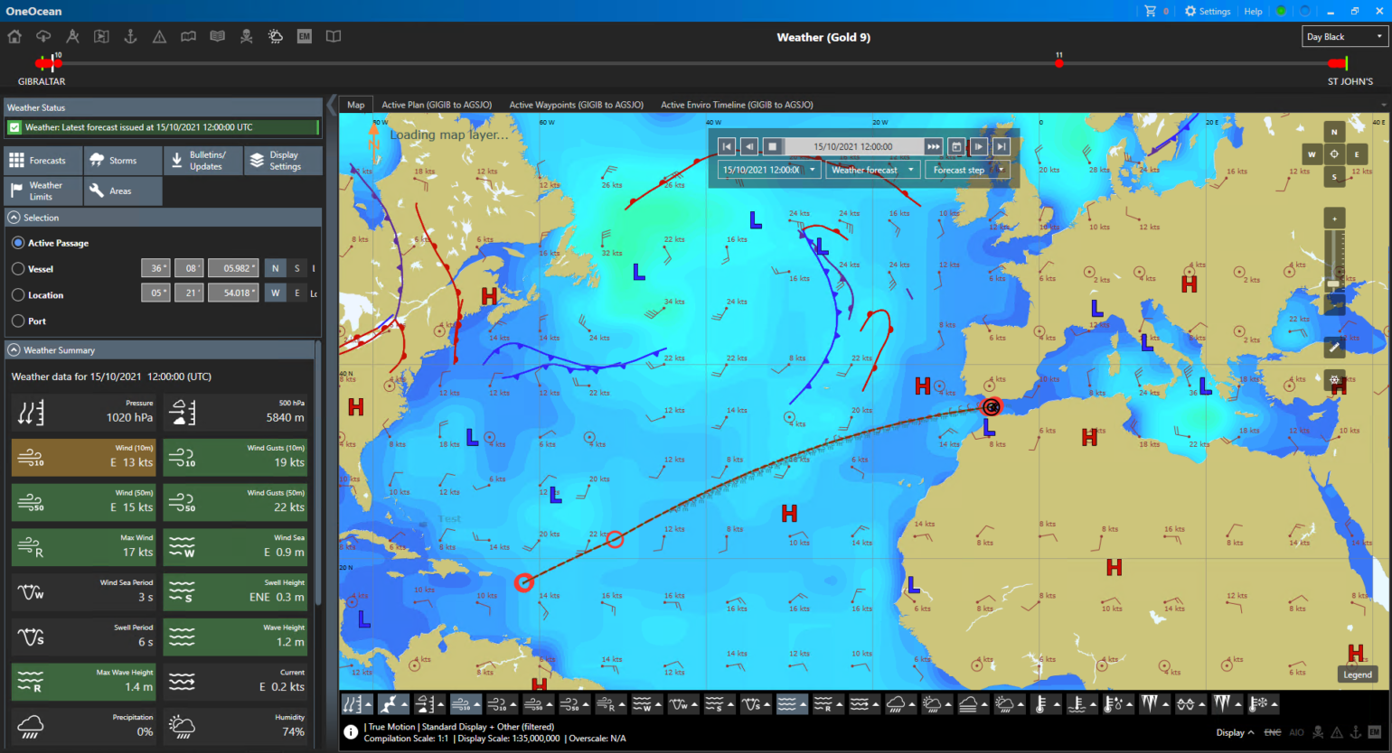
When planning their crossings, yacht crews often use shore-based weather routing services that provide updates on forecasts. These are consulted daily to plan any necessary deviations to routes. With the improvement in routing solutions available, are there further savings that can be made by conducting weather optimisation aboard instead of using paid, shore-based service? OneOcean, a provider of solutions for navigation and compliance management have given us their thoughts on the efficiencies that can be achieved through the weather routing services on their platform.
OneOcean’s software has been developed to optimise weather routing for all vessels, including yachts. The automated weather routing systems use vessel specifications to ensure outputs are as accurate as possible. Complexities such as a vessel’s length and draught, safety margins, and manoeuvrability are all crunched to determine optimal routing through forecasted weather. This level of detail and customisation makes the OneOcean platform extremely powerful and more than equal to the task of providing an efficient route, without the need of shoreside routing support.
Key to OneOcean’s success for weather routing is its use of the best available data to inform its optimisations; both long-range and up-to-the-minute forecasts are used. Meteorological services across the world do an outstanding job combining real and predicted data from multiple sources to forecast precipitation, visibility, wave heights, wind strength and more, with powerful models. This information is updated with high regularity depending on the service used, and OneOcean’s software crunches these numbers from multiple sources to create plans for efficient, stable routes, within acceptable parameters set by the user.
Long range forecasts are vital to the initial route plan. However with longer passages, this original forecast will not remain 100% accurate for the duration of the crossing. Instead, bridge crews are constantly adapting their routes during voyages as new weather data comes in. This ensures the best choices are made to safeguard the vessel and her crew, and conserve fuel. Teamed with its ability to customise recommendations based on safety thresholds set by the user, OneOcean can provide optimised and alternative routes at all times, both before and during the voyage. These choices can immediately be viewed in context to forecasts using the built-in weather simulator, enabling the captain to make flexible, dynamic routing decisions with the best possible information.
Initial routing plans can be made with varying levels of certainty depending on the length of the voyage. Even the most advanced, long-range forecasting techniques struggle for precision in the scope and timing of meteorological events. A yacht travelling a short coastal route can depart with much higher confidence in the weather forecast than one heading across oceans, simply because a forecast spanning days is far more likely to be accurate than one encompassing weeks. The margin of error increases the further ahead you look, and consequently the margins of safety in the voyage plan must extend accordingly.
OneOcean users can enter information about the vessel’s equipment and its unique safety thresholds and create ‘Weather Limits Profiles’ which define vessel-specific safety thresholds for wind speed, wave height and minimum distance from storms. This allows users to ensure that when routes are created, calculations and risk assessments are as accurate as possible. Better still, the software enables dynamic route planning, which links interconnected variables so that when a change is made to one data set, all others that are impacted are updated accordingly. Safety margins are included in passage plans and updated dynamically as the journey progresses and plans change, so that all changes in forecasts are accounted for to ensure that safety limits are still observed. All of this can be monitored by shoreside teams as well through OneOcean’s FleetManager portal.
Making best use of all available data ensures both yacht and crew are kept as safe as possible, facilitates fuel conservation to reduce costs, and ensures that deadlines are met.